Tragedy in Sac Actun: Wrong Turn Leads to Fatal Consequences in Cave Diving Expedition

| Incident Location | Diver Full Names |
|---|---|
| Mexico, Sac Actun | Team B Members (Full Names Unknown) |
December 9th, 2004, nine certified divers made their way to the Sac Actun cave system. They splitted up into two teams with both their own diving plan. One of the teams made a horrible mistake by taking the wrong turn at an intersection, they got themselves into big trouble. On Tuesday morning, December 9th, 2004, two teams were on a diving adventure in the Sistema Sac Actun, also known as “White Cave System”.
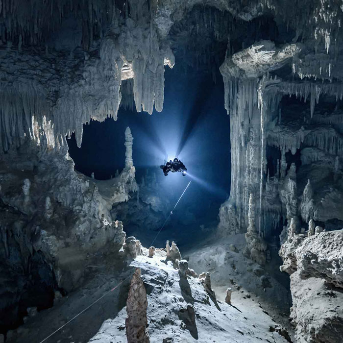
Exploring the Sac Actun Cave System
The cave system is located along the Caribbean coast of the Yucatan Peninsula, Mexico. It is an underwater cave system whose passages extend to both the northern and western parts of the city of Tulum. The exploration of the Sac Actun cave system started in 1987 from the Grand Cenote. Over the years several connections have been explored and mapped by cave divers.
In 2018, they discovered a connection with Dos Ojos was reported, resulting in a 228 miles (368 km) long mapped passages. The connection of the Dos Ojos makes the Sac Actun cave system the longest cave in Mexico and the second longest in the world (behind the Mammoth cave). Over time, several roof collapses have created more than 220 cenotes in the Sac Actun cave system.
The Diving Plan and Teams
The two teams were about to start their Sac Actun adventure to the Cenote Kalimba, which is about 1500 ft (457 m) northwest on the Coba Road from the Gran Cenote of Sistem Sac Aktun. Cenote Kalimba is a shallow cave; its average depth is about 33 ft (10 m). It has a moderate flow according to the standards of Mexico, and it flows southeast towards Gran Cenote.
The two teams came to the diving site with two different vehicles. Team A was a five-member team, consisting of the guide and four other divers. Team B was a four-member team. All were certified and experienced divers. They were prepared to enter and exit Cenote Kalimba according to their diving plan. They planned to follow the permanent guidelines starting from Cenote Kalimba to wherever it ends.
The “Snap-n-Gap” Line
A “snap-n-gap” line that’s about 20 ft (6 m) in length was already fixed within the cave. The line was there as a permanent line having a red aluminum carabiner that is fixed to one end and can be used to further connect other lines instead of a jump or gap reel. The “snap-n-gap” line is directly from the Kalimba line, and the red aluminum carabiner is fixed to the permanent guideline of Paso De Lagarto.
Two white alignment arrow markers that point to the exit of the attachment are also there. When you dive about 65 ft (20 m) away from this “snap & gap” line, the permanent guideline makes a right-angle turn to the right. At this point, the permanent guideline has alignment arrow markers fixed on the downstream side of the right-angle turn.
Dive Plan and Preparation
At 03:10, the diving plan was outlined. The exit side of the dive pointed to the Gran Cenote/Cenote Ho Tul. The team intended to make a short 6 ft (2 m) jump from a right-angle turn using a Delrin spool with a neon pink guideline attached to the Cenote Box Chen guideline. The pink jump spool was meant to be attached upstream of the Kalimba exit side at the right-angle turn.
To ensure clear communication among divers, a non-alignment marker was attached to serve as a reference during exit. The marker also indicated that the snap and gap line was in use. The plan was for two teams, Team A and Team B, to exit together, removing the marker and leaving behind the snap and gap line as they met.
Previous Dive Experience
Two days prior to this ill-fated dive, Team B had dived from Gran Cenote, following the jump spool to the Paso De Lagarta guideline. They had three non-alignment markers to guide them to the exit, with the third marker fixed on the pink gap line for use by both teams.
Diver Routes and Misdirection
At 04:02, Team A planned to follow the guidelines at Box Chen, dive for approximately 500 ft (152 m), and then make a 5 ft (2 m) jump to the left using a spool with a green line. Team B, however, planned to use the non-alignment marker to mark the snap and gap line. They had a Delrin spool with a neon pink line and a non-alignment marker at the right-angle turn, indicating the exit side leading back to the snap and gap line.
At 05:04, Team B reached the snap and gap line after diving upstream along the Kalimba line for 32 minutes. Instead of heading towards Cenote Box Chen as originally planned, they continued diving for another 65 ft (20 m) following the pink gap line connected to the Box Chen line.
Wrong Decision and Navigation Error
While approaching the 6 ft (2 m) jump point, one member of Team B removed a non-alignment marker on the pink gap line, mistakenly leaving behind the non-alignment marker that marked the exit at Cenote Kalimba. Despite seeing the exit marker at the right-angle turn, they made the wrong decision and turned in the opposite direction, diving downstream on the Paso De Lagarto line instead of heading towards the snap and gap line.
Photography and Continued Misdirection
At 06:22, one member of Team B started taking photographs of the cave using a digital camera. He spent approximately 25 minutes taking pictures and ventured as far as 1400 ft (427 m) until he reached the end of the line. Meanwhile, Team B continued in the wrong direction, leaving behind alignment arrows pointing downstream towards Cenote Ho Tul/Grand Cenote.
Discovery of Navigation Error and Desperate Search
At 07:10, Team B realized they were not heading towards the Cenote Kalimba exit as intended. One team member began searching for the correct exit and set up a safety spool. The exit was indicated by an alignment arrow at the end of the Paso De Lagarto line, pointing towards the guideline leading to Cenote Ho Tul/Grand Cenote, approximately 70 ft (21 m) away.
While the search was ongoing, the other three members of Team B remained on the Paso De Lagarto line. After an unsuccessful search for the exit, they turned back and started diving upstream along the Paso De Lagarto. The team member with the camera still had it with him. At this point, they were about 300 ft (91 m) away from the nearest cenote, where they could find safety.
Tragic Outcome and Recovery
The pressure left in their double aluminum 80-tanks was unknown. Dividing themselves into two pairs, the first pair fixed the camera on the permanent guideline when they were approximately 100 ft (30 m) away from the right-angle turn at the Paso De Lagarto line.
Team A had mistakenly removed the non-alignment marker, assuming that Team B had already exited the cave, as they had previously removed the third non-alignment marker. The distance between the first and second pairs of Team A was unknown, but the first pair reported seeing the lights of the second pair behind them.
The first two members of Team B began sharing air while still on the Kalimba line, managing to reach the surface with approximately 500 psi remaining in one of their tanks.
However, the second pair of Team B, despite sharing their air, did not make it to the surface at Cenote Kalimba. They drowned approximately 250 ft (76 m) away from the cenote, and their bodies were later recovered. They had no air left in their double tanks and were found on the cave roof, one with the primary light still on and the other with the backup light on the cave floor beneath him. Their positioning indicated an attempt to share air.
Investigation and Lessons Learned
The bodies of the two deceased Team B members were brought to the surface. Police officers and investigators arrived to collect the bodies and their equipment. It was concluded that Team B had made a navigation error by turning left instead of right at an intersection caused by fixing a jump reel.
This incident might have been avoided if the team had fixed their reel and markers and independently referenced the intersection. The correct navigation would have led them to the Kalimba snap & gap line, which was only about 65 ft (20 m) away. Instead, they traveled in the wrong direction for approximately 1,400 ft (427 m) for 25 minutes.
This tragic event highlights the importance of maintaining a high level of awareness during complex cave dives. It serves as a reminder to take cave diving seriously and remain self-sufficient at all times. Constantly referencing the exit and being aware of one’s surroundings are crucial for survival during cave diving.
The wrong turn made by Team B during a cave diving expedition into Sac Actun resulted in a devastating outcome. Their navigation error led to the loss of two team members’ lives. This incident serves as a sobering reminder of the risks involved in cave diving and the critical need for careful planning, navigation, and situational awareness in such challenging environments.
Before your next dive, consider insurance – it’s like having a dive buddy for unexpected challenges. Dive safe, dive covered. Explore options here
FAQ
The Sac Actun cave system is an extensive underwater cave system located along the Caribbean coast of the Yucatan Peninsula in Mexico. It is one of the longest cave systems in the world, measuring approximately 228 miles (368 km) in mapped passages. The system consists of interconnected cenotes and is popular among cave divers for its unique exploration opportunities.
On December 9th, 2004, two teams of certified and experienced divers entered the Sac Actun cave system for a diving adventure. Team B, unfortunately, made a navigation error by taking the wrong turn at an intersection. They mistakenly dove downstream on the wrong guideline, deviating from their intended route. This led to tragic consequences as two members of Team B lost their lives due to running out of air before reaching the exit.
The navigation error occurred when Team B removed a non-alignment marker on a pink gap line, which marked the exit at Cenote Kalimba. Instead of heading towards the snap and gap line that would lead them back to the intended exit, they turned in the opposite direction and continued diving downstream on the wrong guideline. This decision, combined with the absence of clear communication and reference points, resulted in their misdirection.
The incident might have been avoided if Team B had followed proper navigation protocols and independently referenced the intersection. Fixing their reel and markers, and continuously verifying their location could have guided them to the correct path. Additionally, maintaining situational awareness, clear communication among team members, and constant referencing of the exit are crucial for preventing such tragic incidents during cave diving.
The tragic outcome of this cave diving expedition underscores the importance of careful planning, navigation, and situational awareness in complex cave diving environments. It serves as a sobering reminder of the risks involved and the need for divers to remain self-sufficient and vigilant at all times. Cave divers should prioritize maintaining clear communication, adhering to navigation guidelines, and constantly monitoring their surroundings to ensure their safety and the safety of their team members.